Telegraph Creek is located on the south coast of New South Wales within Jervis Bay Territory. It is classed as a small creek with an intermittently closed entrance.
As part of our water quality monitoring program we assess the water quality and ecosystem health of an estuary using a range of relevant indicators.
Go to estuary report cards to find out what each grade means, read our sampling, data analysis and reporting protocols, and find out how we calculate these grades.
Physical characteristics
| Estuary type | Creek |
|---|---|
| Latitude (ºS) | –35.14 |
| Longitude (ºE) | 150.73 |
| Catchment area (km2) | 4.3 |
| Estuary area (km2) | 0.05 |
| Estuary volume (ML) | 0.7 |
| Average depth (m) | 0.1 |
Notes: km2 = square kilometres; m = metres; ML = megalitres.
Water depth and survey data
Bathymetric and coastal topography data are available for this estuary in our data portal.
Land use
Telegraph Creek is located to the south of the Royal Australian Navy’s HMAS Creswell establishment in Jervis Bay Territory (territory of the Commonwealth of Australia), and almost the entire catchment is forested. There is a popular camping ground, Green Patch, within the catchment as well as a few roads, walking tracks and fire trails.
National and marine parks
- Telegraph Creek estuary and its catchment are situated within the land and waters of Booderee National Park, which includes 875 hectares of marine environment.
Community involvement
- The National Parks and Wildlife Service offers many ways for volunteers to get involved in environmental and educational projects in our coastal national parks.
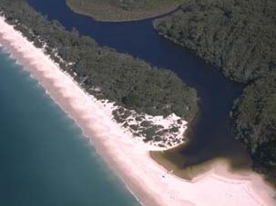
Aerial view of Telegraph Creek estuary.
Local government management
Local councils manage estuaries within their area unless the estuary is attached to a marine park. This estuary is part of the Jervis Bay Territory, which is administered by the Australian Government.
Threatened species
Estuaries provide important breeding, nursery and feeding grounds for many animals, such as fish and birds.
Read more about the biodiversity in our estuaries.